Whāia te ara o te Kareao: Taoka from the Ngāi Tahu Archive
Dec 18, 2025

Whāia te Arao te Kareao: taoka from the Ngāi Tahu Archive
Kareao is the official website of the Ngai Tahu Archive. Named after the ubiquitous supplejack, Kareao is an apt metaphor
for the website which leads from one point to another, linking, connecting, and ultimately taking explorers in directions
of discovery. Whaia te ara o te Kareao is a regular TE KARAKA feature sharing important and interesting stories from the
Ngai Tahu Archive with our readers, which they can explore further on Kareao.
The Kai Tahu Deeds of Purchase
Between 1844 and 1864, most of Te Waipounamu – 34.5 million acres – was ‘sold’ to the Crown in exchange for what Kāi Tahu rakatira later described as the “crumbs that fell from the white man’s table.”
In negotiating these 10 large-scale land purchases, Crown officials offered Kai Tahu miserly sums in payment, applied time pressure, described land boundaries with ambiguity, and threatened to purchase territory from other iwi who were not the rightful
owners.
Kāi Tahu understood that in addition to the small sums of money they received in payment, significant reserves would be set aside, they would have ongoing access to their māhika kai, schools and hospitals would be built, and at least a tenth of some purchase areas would be reserved.
However, the Crown defaulted on the terms of these transactions. Tiny reserves amounting to only one-thousandth of the tribe’s original land holdings were granted, and Kāi Tahu were denied access to their customary food resources. From the 1850s, colonists
quickly outnumbered Kai Tahu on their traditional lands, and by the close of the nineteenth century, 90 percent of tribal members were considered landless.
The Ngāi Tahu Archive holds digital copies of the historic Kāi Tahu deeds, now accessible on Kareao. Photographs of the deeds and accompanying documents were first compiled by historian Harry Evison for his landmark book The Ngāi Tahu Deeds: A Window on
New Zealand History (2006).
Evison gifted his film transparencies and digital scans to the Ngāi Tahu Archive, and they have recently been refreshed with high-definition scans from Archives New Zealand Te Rua Mahara o te Kawanatanga.
Kareao is the official website of the Ngai Tahu Archive. Named after the ubiquitous supplejack, Kareao is an apt metaphor for the website which leads from one point to another, linking, connecting, and ultimately taking explorers in directions of discovery.
Whāia te ara o te Kareao is a regular TE KARAKA feature sharing important and interesting stories from the Ngāi Tahu Archive with our readers, which they can explore further on Kareao.
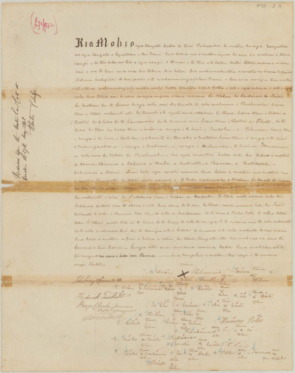
OTAGO DEEDOTAGO DEED 1844
533,000 acres purchased for £2,400
(Equivalent to $364,586 or 68 cents per acre today)
Image (above): R12153214, Archives New Zealand
Signed on 31 July 1844, the Otago Deed was the earliest of the official Kai Tahu land purchase agreements. It transferred land to the New Zealand Company for the planned Scottish settlement of New Edinburgh, later known as Otago.
Unlike many later purchases, the boundaries were carefully defined by leading chiefs Karetai, Taiaroa and Tūhawaiki, who marked them with prominent landmarks and reserved sites at Otago Heads, Maitāpapa and Te Karoro. Kāi Tahu understood that a further one tenth of the land sold within the New Edinburgh block would also be reserved for the iwi. This was never done.
KEMP’S DEED
The Canterbury Deed, also known as the ‘Ngaitahu Deed’, and commonly referred to as Kemp’s Deed, was signed by a group of Kai Tahu chiefs on board the war ship HMS Fly in Akaroa Harbour on 12 June 1848.
It was the largest of all the Crown purchases from Kāi Tahu and the least carefully transacted. The failure the Crown to fulfil its contractual obligations under Kemp’s Deed had such widespread and devastating consequences for Kāi Tahu that for most of the
twentieth century (1909–66) it was the sole focus of Te Kereme (the Kāi Tahu Claim).
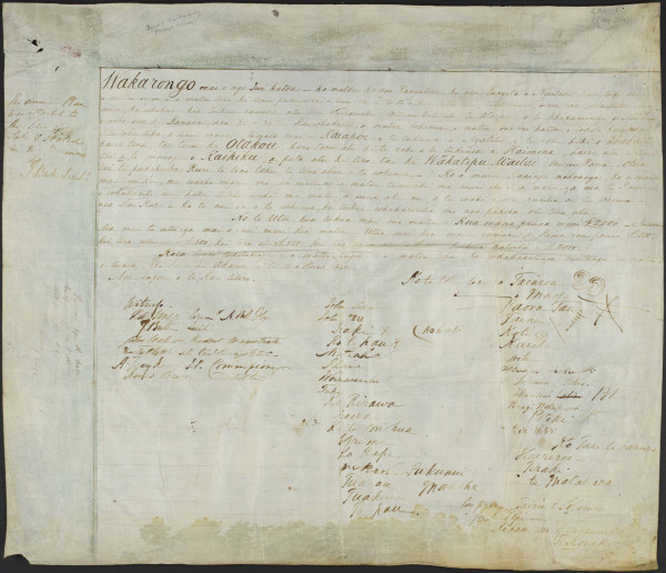

CANTERBURY (KEMP’S) DEED 1848
13.5 million acres purchased for £2,000
(Equivalent to $303,822 or 2 cents per acre today)
Image (above): R12153209, Archives New Zealand
PORT COOPER DEED
The Port Cooper Deed was signed on 10 August 1849 by Kāi Tahu chief Tiemi Nohomutu and 17 others at ‘Oketeupoko’, later known as Ōhinehou (now Lyttelton) in Whakaraupo Lyttelton Harbour. Crown Commissioner Walter Mantell had been instructed to secure the harbour for the new Canterbury settlement.
When Nohomutu insisted it would cost £2 million and include large reserves, Mantell rejected the offer and threatened that Kāi Tahu would lose all claim to reserves if they refused to sign. After bitter negotiations and fearing they would receive nothing, the chiefs relented.
In 1991, the Waitangi Tribunal upheld that the Port Cooper Deed represented a forced sale.
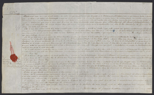

PORT COOPER DEED 1849
65,000 acres purchased for £200
(Equivalent to $30,382 or 47 cents per acre today)
Image (below): R23505338, Archives New Zealand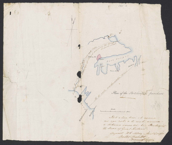
PORT LEVY DEED
Signed at Koukourarata Port Levy on 25 September 1849, the Port Levy Deed transferred 40,000 hectares, two-fifths of Te Pataka-o-Rakaihautu Banks Peninsula to the Crown. After six weeks of wrangling and deception by the Crown’s commissioner Walter Mantell, he secured the signatures of Apera Pukenui, twenty of his supporters and five ‘proxies’.
Though Pukenui sought £1,000 and ample reserves, Mantell offered only £300 and one reserve. Twenty years later Mantell admitted to the Native Land Court: “I am not prepared to swear that any single step taken by me or by the Government with respect to these Natives was fair.”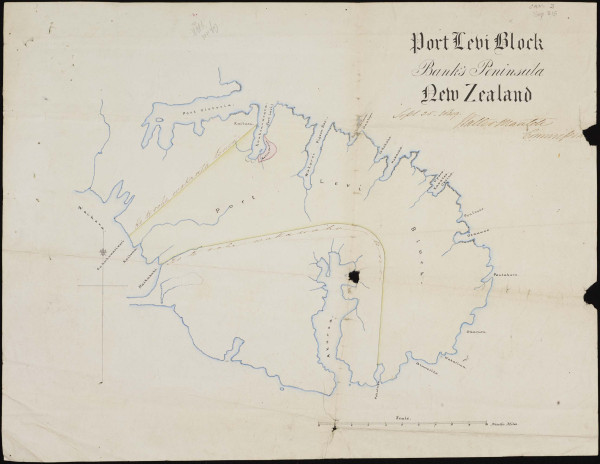
PORT LEVY DEED 1849
98,000 acres purchased for £300
(Equivalent to $45,573 or 47 cents per acre today)
Image (above): R12153210, Archives New Zealand
MURIHIKU DEED
The Murihiku purchase unfolded over three years, from 1851 to 1854. In 1852, before any agreement had been reached with Kāi Tahu, Crown surveyor Charles Kettle was sent south to mark out reserves. The deed was eventually signed at Ōtepoti Dunedin on 17 August 1853, although many signatories were from Otago rather than Murihiku, casting doubt on its validity.
Despite Kāi Tahu protests over inadequate reserves, Mantell ignored requests for more. Promised schools and hospitals were never delivered, and Kāi Tahu have always maintained that Te Rua-o-te-Moko Fiordland was not included in the Murihiku Purchase.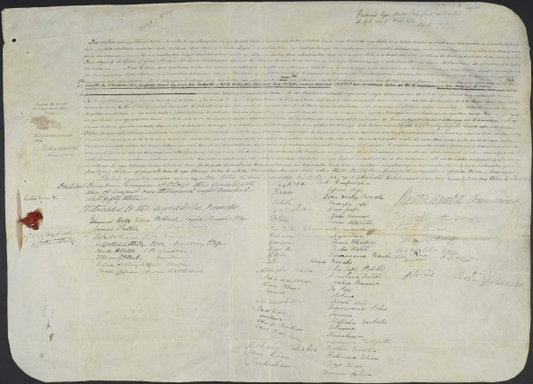
MURIHIKU DEED 1853
7 million acres purchased for £2,600
(Equivalent to $394,968 or 6 cents per acre today)
Image (above): R12153213, Archives New Zealand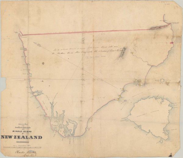
AKAROA DEED
The Akaroa Deed, signed on 10 December 1856, extinguished Kai Tahu title to Te Pataka-o-Rakaihautu Banks Peninsula. Vague and lacking a deed plan, it failed to describe the extent of the land to be sold. Kai Tahu witnesses testified to the Smith-Nairn Commission in 1879 that they were threatened – told the payment would be given to Murihiku people if they refused. The scanty reserves that were allocated proved inadequate, and most peninsula Kāi Tahu were ultimately driven off their land.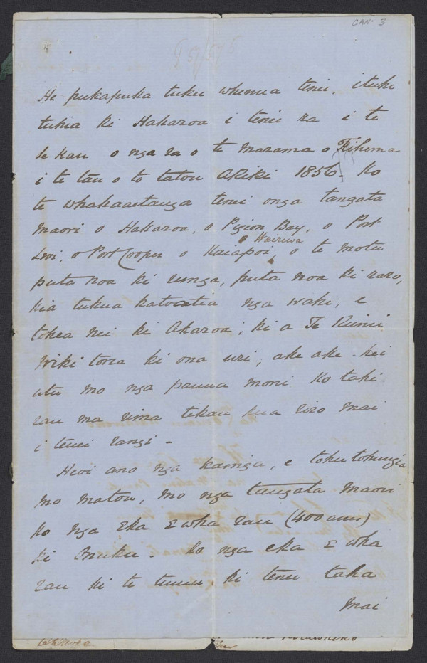
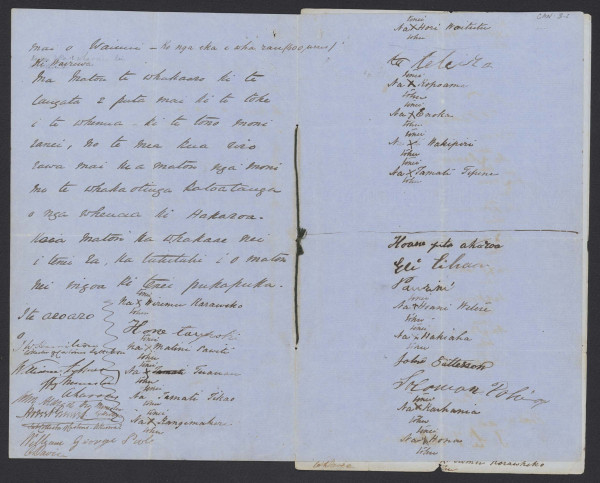
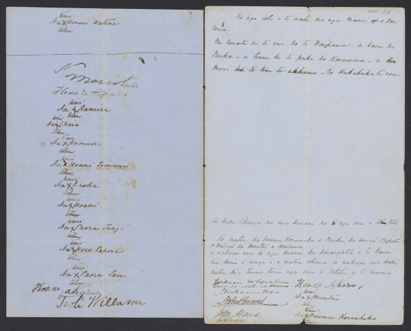
AKAROA DEED 1856
82,000 acres purchased for £150
(Equivalent to $22,786 or 30 cents per acre today)
Image (above): R23505337, Archives New Zealand
NORTH CANTERBURY DEED
For years the Crown refused to consider the Kai Tahu claim north of Kaiapoi up to Te Parinui-o-Whiti, having accepted the claim of Ngati Toa in the Wairau Purchase of 1847. Kāi Tahu never relinquished their claim and the North Canterbury Deed, also known as the ‘Kaiapoi Deed,’ was signed at Tuahiwi on 5 February 1857.
By then all the best land had already been sold or leased by the Canterbury Association or the Crown, although Kāi Tahu had never received payment. Despite Kāi Tahu requesting reserves that would support their participation in pastoral farming, no provision was made for Kāi Tahu to retain any of its land.
NORTH CANTERBURY DEED 1857
2.1 million acres purchased for £500
(Equivalent to $75,955 or 4 cents per acre today)
Image (below): R12153211, Archives New Zealand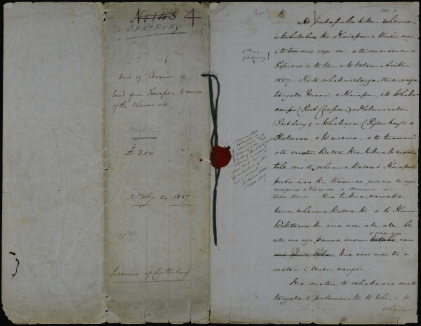
KAIKŌURA DEED
The Kaikōura Deed was signed on 29 March 1859 by 25 Kāi Tahu chiefs led by Kaikoura Whakatau. Like in North Canterbury, the Crown considered it had already purchased the land from Ngāti Toa and had subsequently leased most of it to settlers, thus reducing the leverage Kāi Tahu had to negotiate terms. When negotiations finally occurred, the claims of Kaikōura Whakatau were dismissed.
Kāi Tahu was forced to sell 2,817,000 acres for a token sum of £300. Although coastal reserves of 5,558 acres provided valuable access to māhika kai, Crown agent James Mackay Jr described them as being of the “most useless and worthless description.”
ARAHURA DEED
The Arahura Deed was signed at Mawhera on 21 May 1860 by leading Poutini Kai Tahu including two wahine, Purua and Meri Te Aowhangai, surrendering nearly three million hectares to the Crown in return for £300 and 10,224 acres in reserves.
Mackay Jr had been instructed to secure the land as cheaply as possible, especially after gold was discovered on the West Coast. Despite initial resistance, Kai Tahu were pressured into accepting the offer. The Kāi Tahu vendors retained the Arahura River and limited reserves. The deed was almost lost the next day when Mackay’s waka capsized on the Māwhera River.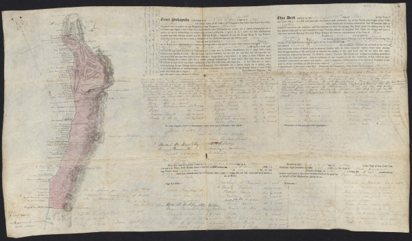
ARAHURA DEED 1860
7.4 million acres purchased for £300
(Equivalent to $45,573 or 1 cent per acre today)
Image (above): R12153539, Archives New Zealand
RAKIURA DEED
The Rakiura Stewart Island Purchase was the last of the major land purchases from Kai Tahu by the Crown.
The Rakiura Deed was signed by 34 Kai Tahu and Kati Mamoe representatives at Awarua Bluff on 29 June 1864. It
conveyed Rakiura to the Queen along with “all the large islands and all the small islands adjacent.” Nine reserves
amounting to about 935 acres were set aside on the island, plus an unspecified amount at “The Neck” for those of
‘mixed descent.’ The Crown also agreed to protect and preserve the rights of Rakiura Maori to access the nearby islands
used for harvesting titi.
2.1 million acres purchased for £500
(Equivalent to $75,955 or 4 cents per acre today)
Image (below): R12153211, Archives New Zealand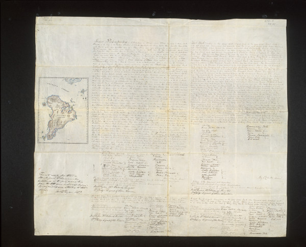
EXPLORE THE DEEDS FURTHER ON KAREAO (www.kareao.nz)
These important records feature in Kā Whakatauraki: The Promises, a new exhibition at Christchurch Art Gallery Te Puna o Waiwhetū
(15 November 2025 – 7 March 2027).
For the first time since the mid-1800s, the 10 original land purchase agreements and accompanying documents are on public display, illuminating the promises made and the injustices wrought upon Kāi Tahu during a critical and formative period in New Zealand history.
Kā Whakatauraki: The Promises
Dates: 15 November 2025 – 7 March 2027
Venue: Christchurch Art Gallery Te Puna o Waiwhetū
RAKIURA DEED 1864
420,000 acres purchased for £6,000
(Equivalent to $911,466 or $2.20 per acre today)
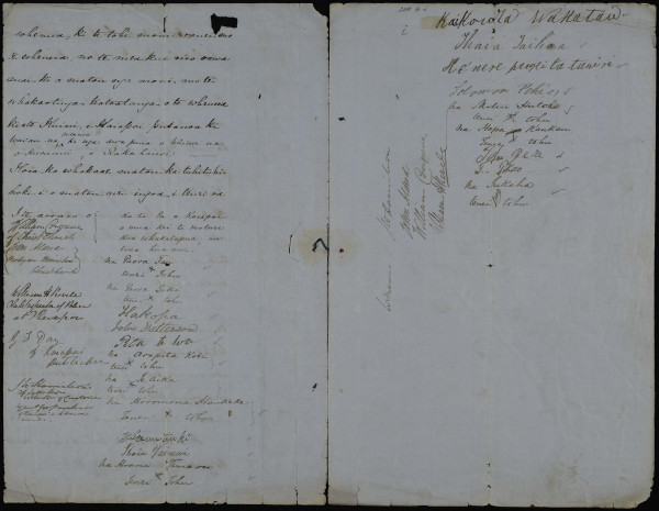
Image (above): 2014-104, Harry Evison Collection,
Ngai Tahu Archive
This large-scale topographic map of Te Waipounamu (right) annotated with the boundaries of the Kai Tahu land purchases hung on the wall as a visual aid and backdrop to the Kāi Tahu Waitangi Tribunal hearings held at various locations throughout Te Waipounamu between 1987 and 1991.
NT9-S61, Ngaitahu Maori Trust Board Collection, Ngai Tahu Archive