Mana Recognition
A number of ‘instruments’ have been created to recognise Ngāi Tahu’s mana in relation to a range of sites and areas, and to provide for this to be reflected in the future management of these sites. They are:
Statutory Acknowledgements
Statutory Acknowledgements significantly enhance the ability of Ngāi Tahu to realise the full potential which the RMA offers as a tool for incorporating Māori values into the management of the environment.
The Statutory Acknowledgement (SA) is a new instrument, which was created as part of the Crown’s Settlement Offer. The aim of the instrument is to improve the effectiveness of Ngāi Tahu participation under the Resource Management Act (RMA), and the protection that areas significant to Ngāi Tahu receive under that Act. Local councils are already required to recognise and provide for the relationship of Māori with their lands, waters and other taonga.
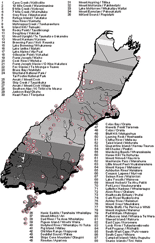
SAs will be given effect by recording a statement of the Ngāi Tahu association to each of the 64 areas shown on the map (see map) and in the settlement legislation.
SAs will have four practical outcomes:
- Noting on plans – The existence and location of the SAs will be shown on relevant district and regional plans and policy statements prepared by councils, meaning that people applying for resource consents will be on notice that these areas are special to Ngāi Tahu.
- Notice of Applications – Whenever a council receives an application for a resource consent relating to, or impacting on, one of the SA areas, it will be required, for a period of 20 years following the settlement, to send notice of that application to Te Rūnanga o Ngāi Tahu, so that the tribe will be aware of potential developments while there is still time to take part in the process.
- Standing – When councils, the Environment Court (formerly the Planning Tribunal) and the Historic Places Trust make decisions in relation to the SA areas about who has the right to comment and be listened to, or to appear in Court, they must have regard to the SA.
- Evidence – The SA may be produced by Ngāi Tahu in any proceedings under the RMA or Historic Places Act as evidence of its relationship with the particular area.
Statutory Acknowledgements significantly enhance the ability of Ngāi Tahu to realise fully the potential which the RMA offers as a tool for incorporating Māori values into the management of the environment. They do not:
Create any property rights for Ngāi Tahu.
- Affect the property rights of anybody else.
- Give Ngāi Tahu a veto right in RMA decisions.
Deeds of Recognition
DoRs apply to the same areas as the SAs shown on the map (see map above) and complement them by providing for Ngāi Tahu input into the decision-making processes of the Crown body responsible for the administration of each of those areas.
DoRs take the form of specific agreements between Ngāi Tahu and the landholding agency (either DoC or Land Information New Zealand – LINZ). They recognise the Ngāi Tahu historical, spiritual, cultural and/or traditional relationship with each of the areas, and the mana and tangata whenua status which results from that relationship. DoRs also create an obligation on DoC or LINZ to consult with Ngāi Tahu and to have particular regard to its views in relation to the management of each of the areas.
The combination of DoRs and SAs provide Ngāi Tahu with input into decisions made by the Crown as a landowner in these areas, and, through the RMA, into decisions about the activities of the Crown or any other persons which affect the areas.
Through these instruments, the mana of Ngāi Tahu is recognised and given operational effect in day-to-day management.
Tōpuni
Tōpuni provide very public symbols of Ngāi Tahu mana and rangatiratanga over some of the most prominent landscape features and conservation areas in Te Waipounamu.
The concept of Tōpuni derives from the traditional Ngāi Tahu tikanga (custom) of persons of rangatira (chiefly) status extending their mana and protection over a person or area by placing their cloak over them or it. In its new application, a Tōpuni confirms and places. An ‘overlay’ of Ngāi Tahu values on specific pieces of land managed by DoC. A Tōpuni does not override or alter the existing status of the land (for example, National Park status), but ensures that Ngāi Tahu values are also recognised, acknowledged and provided for.
Each Tōpuni involves three levels of information:
- A statement of the Ngāi Tahu values in relation to the area (just as for the SA and DoR).
- A set of principles aimed at ensuring that DoC avoids harming or diminishing those values – for example “encouragement of respect for the association Ngāi Tahu has with Aoraki”.
- Specific actions which DoC has agreed to undertake to give effect to those principles (such as “educational material will be made available to climbers and all climbing guides explaining that to Ngāi Tahu, standing on the very top of Aoraki denigrates its tapu status”).
The specific actions may change over time as circumstances change, but Conservation Boards will always be required to have particular regard to the Ngāi Tahu values in relation to each area, and to consult and listen to Ngāi Tahu when they prepare plans and strategies in relation to these areas.
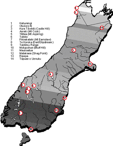
Tōpuni have been created over 14 areas of land of significance to Ngāi Tahu (see map below).
Tōpuni will provide very public symbols of Ngāi Tahu mana and rangatiratanga over some of the most prominent landscape features and conservation areas in Te Waipounamu.
Dual Place Names
Place names are a significant symbol of the relationship Ngāi Tahu has with the landscape, The re-establishment of traditional place names in a variety of areas serve as tangible reminders of our history in Te Waipounamu.
The Crown’s Settlement Offer provided for 88 place names to be changed (see map below). The name Whareakeake replaces the name Murdering Beach (Otago Peninsula), but in all other cases names are to be joint English/Maori names. The one exception is Aoraki / Mount Cook, where the Māori name comes first. These new names will be included on official maps and road signs and explanatory materials as those things are replaced over time.
The New Zealand Geographic Board – the body which is responsible for the official naming of places and landscape features has been given the additional function of encouraging the use of original Māori place names. Ngāi Tahu also has a dedicated seat on the Geographic Board (see Dedicated Memberships).
The re-establishment of traditional place names in a variety of areas will serve as tangible reminders of our history in Te Waipounamu.