Don’t just look at the pictures
Jul 2, 2017

Māori archaeologists are few and far between, but at the end of 2016 Gerard O’Regan and Chris Arnett, both Ngāi Tahu, graduated as Doctors of Archaeology. They follow in the footsteps of Professor Atholl Anderson (also Ngāi Tahu), a world leader in Pacific archaeology, and our pre-eminent archaeologist. Last year, Atholl received the 2016 Prime Minister’s award for Literary Achievement, recognising his massive contribution to New Zealand writing, including several books and many articles on southern Māori heritage. As Chris and Gerard carry the research on into the future, they are quick to point out that rock art is more than just pictures – it’s a vital window on indigenous peoples’ relationship with the whenua, and in some cases, a fascinating record on how they dealt with early European contact.
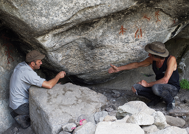
Gerard O’Regan (left) and Chris Arnett figuring out how to excavate beneath red paintings at Tcutcuwi’xa.
In 1990, Atholl Anderson and Brian Allingham were responsible for getting the Ngāi Tahu tribal rock art project kick started. Twenty-five years later, on different sides of the Pacific, both Gerard and Chris have also been immersed in rock art heritage. The pair first met a few years ago at a rock art symposium in Barcelona, and immediately realised the parallels in both their research and their whakapapa. In May 2016, with their PhDs finished, they got together in British Columbia to support a local Indian band excavate at an important rock shelter, and to talk at the Nlaka’pamux Rock Art Conference, hosted by the Nlaka’pamux Nation Tribal Council, in Lytton, British Columbia.
Gerard has been involved in Ngāi Tahu heritage issues for over 30 years. His enthusiasm for archaeology and his affiliation to Te Rūnanga o Moeraki, who are kaitiaki for rock art in North Otago, saw him take on the management of the rock art project after Atholl shifted to Australia, and then lead the set-up of the Ngāi Tahu Māori Rock Art Trust. When the whānau shifted to Auckland, Gerard went back to university, completing a master’s and then a doctorate in archaeology, both focused on Māori rock art.
Chris grew up in British Columbia, where his maternal heritage extends back five generations. But the huge “Poutama” sign at the gate of his parents’ house on Vancouver Island announces that these Canadians are also Ngāi Tahu. Chris’s father, John Arnett, grew up in Murihiku, and still reflects on his time muttonbirding on Poutama, one of the Tītī Islands. Staunchly proud of his own taha Māori, Chris has been involved in First Nations’ heritage for many years. This inspired his doctoral research in the Stein Valley, a native landscape that escaped a close call with road building and industrial logging in the 1980s. It is now a Class A provincial park co-managed with Lytton First Nation, and serves as a cultural and natural refuge for the local Nlaka’pamux Nation and their visitors. Several rock art sites continue to be visited in the Stein, and the paintings feature prominently in community life.
Nlaka’pamux rock art has some of the richest surviving traditions and archaeological information in North America. It offers a rare opportunity to study indigenous rock art with a clear window into the historical context. Some archaeologists argue that a great deal of North American rock art is related to shamanism – a religious practice in which tohunga go into a trance to travel into the spiritual world.
Nlaka’pamux shamans made paintings as well, but Chris prefers not to impose broader Western theories to explain the rock art in the Stein Valley, and instead looks at it as a signature of localised Nlaka’pamux cultural practice. According to their oral traditions, the painting is an ancient practice, but many of the images visible today were put on landforms special to the Nlaka’pamux after the arrival of Europeans and the killer pathogens such as smallpox on the faraway east coast of North America. The stories tell that Nlaka’pamux knew of Europeans before they ever met face-to-face, and actively tried to lessen the impact of contact through cultural practices including speeches, dances, and rock painting.
Rock painting is known to have occurred at 50 locations along travel corridors throughout the territory, from as early as the 16th century up until the 20th century. By combining information available from multiple sources including anthropological texts, historical writing, archaeological data, and local indigenous knowledge, Chris argues that images painted with red ochre were produced by Nlaka’pamux in exceptional historical circumstances of cultural emergency. “It was a pro-active intervention in the issues of the day with the protection of people, community revitalisation, and intergenerational memory in mind,” Chris says.
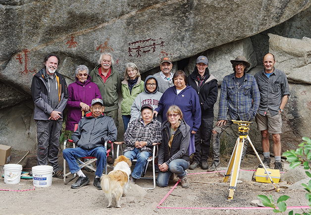
Upper Similkameen Indian Band’s Tcutcuwi’xa Shelter 2016 excavation team. Chris Arnett and Gerard O’Regan at far right.
Developing a better understanding of places with rock art is also on the agenda of the Upper Similkameen Indian Band of the Okanagan Nation in southern British Columbia, where both Chris and Gerard worked in May 2016. A shelter named Tcutcuwi’xa on their Chuchuwaya Indian Reserve was once excavated by scholars, but the Band was unsatisfied with the interpretations that emerged. With their local archaeologist Brenda Gould, they initiated a new investigation to try to better understand the significance the place had for people over time. This involves looking at the archaeological “site formation processes” to find out how all the different aspects of the site, from the largest rock formation, to the position of the smallest artefact in the ground or red ochre pictograph on the rock wall, came to be as we see them today.
In the world of rock art, this kind of detailed examination is exemplified in the study of the famous Chauvet Palaeolithic cave in southern France. This was especially brought to the attention of Ngāi Tahu in 2013 when world rock art expert Jean Clottes visited New Zealand for a lecture tour which included screenings of a film about Chauvet, Cave of Forgotten Dreams.
International archaeologist Jean-Michel Geneste and geomorphologist Jean-Jacques Delannoy brought their experience of that extraordinary cave to the Tcutcuwi’xa study. The French team are documenting the project, which is also assisted by the Museum of Anthropology at the University of British Columbia.
The first field season brought together various technologies to capture different kinds of information. Elders were videoed sharing memories, and inaccessible parts of the rock bluff were explored with a high-flying drone. The undisturbed ground was examined with ground-penetrating radar, a laser scanner digitally mapped the shelter, and a 3D computer model of the excavation pits was created right there on-site. A new tablet app designed for rock art research allowed digital photographs to be instantly enhanced in the field, bringing into view the often faded detail of the paintings.
But despite the flash electronic gadgets, the dusty work of archaeological trowelling, sieving, sketching, and note writing still needed to be done. For more than a week Chris and Gerard scraped through rubble directly beneath bold red paintings to find a fireplace, butchered game bones, and artefacts (including an exquisite stone spear point) that are likely to be hundreds or perhaps thousands of years old.
Band members who grew up near the Tcutcuwi’xa shelter have traditions and histories about past activities and the cultural significance of the place. Paintings of people riding horses and wearing hats may recall the European contact period, and it has been suggested that a line drawn through the necks of four human figures shows prisoners roped together (pictured on the rock wall behind the excavation team portrait opposite). Such interpretations are a grim testament to how the colonial experience is remembered.
Here in New Zealand, we have few histories for specific places with rock art. Gerard’s doctoral research followed a similar approach to Chris’ work in the Stein Valley and the Tcutcuwi’xa project by trying to understand the relationship between the changing landscape and rock art in it. His thesis is He Ana, He Whakairo: Examining Māori belief of place through the archaeological context of rock art. Focusing on sites near Taupō and at Opihi in South Canterbury, it pulls together insights from histories, place names, examination of carvings and paint pigments, and excavations around rock art. Gerard questions if looking at how rock art is placed on the land allows traditional Māori ideas about those localities to be studied with archaeological methods.
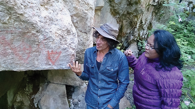
Chris talks with Stacy Thom, Nlaka’pamux Nation, about painted bear paws in the Stein Valley. The fine for disturbing the rock art there is up to $1,000,000.
For example, at Opihi there are a number of Māori names written in missionary-style script surrounding older rock art images. Some scholars didn’t consider the writing to be “rock art”, but the same type of writing was used in tapu practices like 19th century meeting house carvings and tā moko. To Gerard this shows that the written names were symbolically important to Māori at the time. “Writing on the rock shelters next to older paintings suggests a new style of expression that was still part of a traditional practice of marking the land. Perhaps it was reaffirming the relationship of the named people with the place at a time of rapid change during missionary teachings and land dispossessions.”
If we think about the people first, rather than defining places as “rock art landscapes”, we should think more about “landscapes with rock art” … “Don’t just look at the pictures.”
Chris Arnett Ngāi Tahu, Doctor of Archaeology
It turns out though there are only a few cases where traditional Māori beliefs about places can be demonstrated by archaeology, as historic land use tends to prevent that. The effects of original Māori bush clearance, modern farming, forestry, and natural erosion all contribute to the poorly-preserved state of archaeological deposits, rock art, and surrounding natural features. The geographic detail in traditional Māori knowledge also dims over time, particularly when generations of people were prevented from accessing their traditional places. These issues make it difficult to include mātauranga Māori in heritage assessments, because New Zealand law only automatically protects very specific archaeological evidence. “If New Zealand is really serious about protecting the Māori heritage values of those places, then we need to change the way we actually think about archaeology and archaeological evidence,” Gerard says.
Gerard shared these thoughts at the Nlaka’pamux Rock Art Conference in Tl’kémtsin (Lytton), British Columbia, the first-ever rock art conference run by indigenous people in North America. Chris was part of the team organising the conference, and also presented his PhD results. Rather than romanticise the pictures, most of the First Nation presenters focused on understanding the cultural relationships to the places with rock art, as well as the surrounding landscapes. This reinforces the ideas in both Chris’ and Gerard’s PhDs: to look broadly at what else can be known about the wider localities. Landscapes have been a particular focus in international rock art research over the last decade but if we think about the people first, as Chris notes, rather than defining places as “rock art landscapes”, we should think more about “landscapes with rock art”. Putting it another way: “Don’t just look at the pictures.”
The international rock art research community is small, so Gerard and Chris meeting up is not as unlikely as it may seem. More coincidental is that they’ve developed similar thinking at the same time, but perhaps that reflects their drive for indigenous heritage, fired up by their Ngāi Tahu whakapapa. They have already talked about ideas of linking indigenous rock art researchers in the Pacific and exploring rock art in Murihiku. Whatever the case, future collaboration is certain.
Gerard is now doing post-doctoral research on North Island Māori rock art at the University of Auckland, while Chris is pursuing archaeological and ethnographic contract work with Coast and Interior Salish First Nations, as well as turning his PhD into a book with University of British Columbia Press. Gerard will be in Austria later this year for an international workshop on rock art research practices, where he will lead a session on indigenous and community perspectives. “We’re expecting a focus on questions of how archaeology can much better serve indigenous peoples’ kaitiakitanga of these places,” Gerard says.
“If we look beyond the pictures when thinking about our rock art taonga, we’ve only just started to scratch the surface, so to speak, and there is still a lot to do”.
Chris and Gerard were wonderfully hosted by the Upper Similkameen Indian Band, Brenda Gould and Wilson Wiley’s whanau and the Nlaka’pamux Nation Tribal Council. Guillaume Le Berre supplied the Tcutcuwi’xa photos and the University of Auckland Te Whare Wānanga o Tāmaki Makaurau provided travel assistance. He mihi mahana ki a rātou.